Moorland Ridges and Summits
View interactive map of Broad Character Areas
Key Characteristics
- Broad divided ridges and high flat-topped summits.
- A strong horizontal grain to the topography.
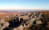
- Grits and limestones outcrop locally in low grey crags and stone bands.
- Hard igneous dolerites outcrop in larger crags and scree slopes.
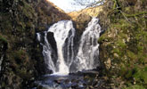
- Rocky, quick flowing becks or burns in steep sided gullies.
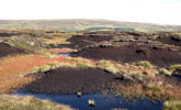
- Extensive tracts of blanket bog of heather, cotton grass and sphagnum mosses.
- Deep peat exposed in eroded hags and peat edges.
- Drier slopes clothed in upland heath of heather and bilberry or acid grasslands.
- Extensive grazing by hardy hill sheep.
- Burning patterns on grouse moors create a patchwork of older and younger heather.
- Few man made features other than occasional fences, grouse butts, cairns and sheepfolds.
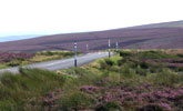
- Unfenced roads marked by snow poles with gates or cattle-grids at the moor wall.
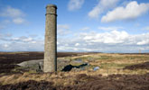
- Relics of lead mining – bell pits, hushes, waste heaps, railways, reservoirs and water leats, smelter flues and chimneys.
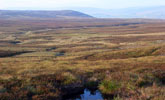
- Panoramic long distance views out across unbroken moorlands or adjoining dales.
- A remote and elemental landscape with a near wilderness quality in places.
Description
Remote upland landscapes of elevated moorland ridges and high summits. The topography of the landscape is heavily influenced by its geology. Alternating strata of Carboniferous limestones, sandstones and softer shales give a stepped profile to slopes and a strong horizontal grain to the topography. Millstone grits cap the higher fells and form distinctive flat-topped summits. Thick layers of peat cover much of the terrain but underlying rocks outcrop locally to form low grey scars and stone bands. Igneous dolerites of the Great Whin Sill form prominent crags and screes. Ridges are broad and deeply divided by valleys on their flanks, drained by rocky, quick-flowing becks or burns in steep sided gullies – gills or sikes. Thick peats are exposed as dark eroding peat edges and hags.
The highest ground is occupied by extensive tracts of blanket bog of heather, cotton grass and sphagnum mosses. This gives way on drier ground to moorland of heather and bilberry or acid grassland on peaty gleys and podzols. The moors are managed for grouse shooting and the extensive grazing of hardy upland breeds of sheep like Swaledales. On heavily grazed moors heather is replaced by ‘white moor’ dominated by Mat-grass. Burning patterns on grouse moors create a patchwork of older and younger heather, creating a diversity of colour and texture.
The landscape is largely devoid of man made features other than occasional fences, grouse butts, cairns, sheepfolds and bields. Roads across the moor are unfenced and marked by snow poles with gates or cattle-grids at the moor wall. Occasional radio and telecommunications masts break the skyline.
Relics from the Bronze Age survive in a few places in the form of stone circles, cairn fields and burial mounds – these are generally cryptic features, difficult to find in the moorland heather. Remains of the 18th and 19th century lead mining industry – including bell pits, mine entrances, derelict mine buildings, waste heaps, reservoirs and water leats – can be found on some moors following the line of ore-bearing veins. The most prominent in the landscape are smelter flues and chimneys and the deep hushes which scar the hillsides and occasionally notch the skyline.
The landscape is visually very open with panoramic long distance views out across unbroken moorlands or adjoining dales. The visual simplicity of the landscape coupled with a severe climate of high rainfall, cold winters and short summers gives it an austere and elemental character. In the heart of the moorlands, where man-made features are few, the landscape has a near wilderness quality.
Broad Character Areas
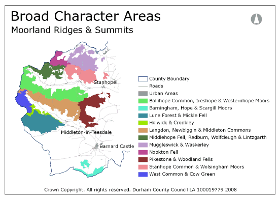
The Moorland Ridges and Summits landscape type is represented by eleven broad character areas.
View interactive map of Broad Landscape Character Areas
Barningham, Hope and Scargill Moors. Moorland slopes to the south of the Greta around the large forestry plantation of The Stang. The high ridge top of Hope moor is clothed in blanket bog or the ‘white moor’ of modified bog. The lower moors of Barningham Moor and Scargill Low Moor are drier heath with a mosaic of burning patterns. Barningham moor contains relics of a Bronze Age ritual landscape including a stone circle, cup and ring marked stones and burial mounds.
Bollihope Common, Ireshope and Westernhope Moors. The high watershed between Weardale and Teesdale and the South Tyne is divided into a series of moorland valleys. The high ridges of Burnhope Moor in the west are clothed in blanket bog; elsewhere the moors are heavily grazed white moor of acid grassland and modified bog. There are lead mining remains in some valleys together with a number of old ganister and limestone quarries. The moors are crossed by minor roads connecting the dales. There are dramatic long distance views from higher ground across Weardale to the northern moorland ridges.
Holwick and Cronkley. The Great Whin Sill is exposed in prominent scars along the southern flanks of Teesdale at Holwick, Cronkley and Falcon Clints and in the dramatic waterfalls of Cauldron Snout and High Force. Low moors lie along the foot of the scars at Cronkley Pasture, and open Juniper woods fall to the fast flowing and peaty River Tees. Whinstone quarries follow the outcrop including a currently active quarry at Force Garth.
Langdon, Newbiggin and Middleton Common. The southern slopes of the high watershed between Teesdale and Weardale are divided into a series of moorland valleys. The ridge top and outlying spurs are clothed in blanket bog. The valleys are heavily grazed ‘white moor’ of acid grassland and modified bog. The landscape is rich in lead mining remains including prominent hushes such as Coldberry Gutter, and there are a number of old ganister quarries high on the moorland ridge. The moors are crossed by minor roads connecting the dales. There are dramatic long distance views from higher ground across Teesdale to the summits ridge beyond.
Lune Forest and Mickle Fell. High moorlands of blanket bog lying in the western summit ridge of the North Pennines. At 758m AOD Mickle Fell is the highest point in the county, its flat-topped summit fringed with screes and stone bands. The ridge is divided by minor valleys in the south where it borders onto Lunedale, and in the east falls with a stepped profile to Teesdale where lower moors of acid and calcareous grassland lie above the Whin Sill scars of Holwick and Cronkley. A remote wilderness accessed by few paths or tracks with dramatic views along the summit ridge and south across the moorland plateau.
Middlehope Fell, Redburn, Wolfcleugh and Lintzgarth. The high watershed between Weardale and Allendale is divided by the moorland valleys of Rookhope and Middlehope. The ridge is clothed in blanket bog, the valleys and moorland slopes in white moor of acid grassland. The landscape has been heavily affected in places by lead mining and quarrying, most notably in Rookhope Head. The moors are crossed by minor roads connecting the Durham dales with Tynedale and Allendale. There are panoramic views from high ground across the surrounding dales to the moorlands beyond.
Muggleswick and Waskerley. The broad ridge between Weardale and Derwentdale is divided by a number of valleys of dry heather grouse moor with prominent burning patterns and frequent shooting butts. Several small reservoirs lie in the eastern valleys. Edmundbyers Common contains many lead mining remains including the landmark Jeffries and Sikehead chimneys. The moors are crossed by a number of well-used roads connecting the dales, and by the Waskerley Way on the old Stanhope-Tyne railway line.
Nookton Fell. High flat-topped ridges of blanket bog encircle the moorland valley of the Nookton Burn. The moors are crossed in the east by a minor road connecting Rookhope and Derwentdale but are otherwise remote and accessed by few paths or tracks.
Pikestone and Woodland Fells. A broad arc of moorland valleys of dry heather grouse moor falling from a high ridge of blanket bog marked by a series of low pikes including Five Pikes, Pawlaw Pike and Islington Hill. The moors are drained by tributaries of the Bedburn Beck, which lie in incised steep sided ravines and fall to Hamsterley Forest in the moorland fringe.
Stanhope Common and Wolsingham Moors. Moorland ridges and valleys on the northern flanks of Weardale. Blanket bog on the ridge-tops gives way on the slopes to drier heath with a mosaic of burning patterns. The moors are crossed by the main road between Weardale and the Derwent valley, and by the Waskerley Way, which follows the Crawleyside and Weatherhill Inclines. There are commanding views across Weardale from the higher ground.
West Common and Cow Green. High moorlands of blanket bog which include the gently sloping moorland ridge of Herdship and Widdybank Fells and the remote moorland valley headwaters of the River Tees. The large Cow Green reservoir occupies the lower reaches of the valley. Sugar limestones on Widdybank Fell support calcareous grasslands which contain rare Arctic or Alpine plant communities including Spring Gentian and the Teesdale Violet. An austere wilderness accessed by few paths or tracks with dramatic views to the west of the higher Pennine summits.
Local Landscape Types
Local Landscape Types and sub-types are identified at a detailed level and reflect localised variations in landscape characteristics. A map of the Local Landscape Types and sub-types for the Moorland Ridges and Summits Broad Landscape Type can be downloaded as a pdf below:
Local Landscape Types – Moorland Ridges and Summits Map (PDF, 850kb)
Alternatively you can view an interactive map of Local Landscape Types for the whole of the North Pennines County Character Area.
For a written description of the Local Landscape Type and sub-types for the North Pennines County Character Areas download the following PDF:
North Pennines Local Landscape Types (PDF, 1Mb)
Further Information
Further Broad Landscape Types with in the North Pennines
or

