
Lowland River Terraces
View interactive map of Broad Landscape Types
Key Characteristics
- Flat, narrow floodplain fringed in places by low, steep-sided bluffs.
- Coarse loamy and sandy soils on alluvial river terrace drift.
- Meandering rivers with alternating riffles and pools.
- Arable cropping on the floodplain.
- Semi-improved pastures on bluffs.
- Low hawthorn hedges with scattered hedgerow oak and ash.
- Fragments of rigg and furrow survive in older pastures.
- Ancient oak woodlands on steeper bluffs.
- Narrow riparian woods or tree lines of alder, oak, ash and willow on river banks.
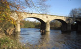
- Old villages closely associated with the river, often on bridging or fording points.
- Buildings of local stone with roofs of slate or clay pan tile.
- Occasional recreational sites – lidos and caravan parks.
- A visually enclosed landscape of an intimate scale.
- A settled but tranquil rural landscape of high scenic quality and historical depth.
Description
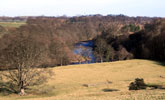
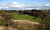
Flat, narrow (200-400m) floodplains merging with the gently rolling topography of the wider vale or fringed by steep-sided bluffs. Rivers are meandering with alternating shallow, quick flowing riffles and broader slow moving reaches. Soils are coarse loamy or sandy brown earths on alluvial river terrace drift.
Agricultural land use is mixed, with arable cropping – mostly of cereals – on the flat floodplain haughs and improved and semi-improved pastures on the steeper ground of bluffs and valley sides. Field boundaries are hedgerows with scattered hedgerow oak and ash. Field systems are generally irregular or sub-regular in pattern, dating from the enclosure of common meadows and pastures of the surrounding villages in and around the 17th century. They include many older boundaries and occasional fragments of rigg and furrow in less improved pastures.
The landscape is well wooded, with ancient oak woodlands on steeper bluffs overlooking the floodplain and narrow riparian woods or tree lines of alder, oak, ash and willow on the river banks.
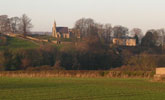
The floodplain terraces are followed by a chain of old villages that are closely associated with the river, often on bridging or fording points. Villages are of Saxon or later medieval origins with buildings of local stone with roofs of slate or clay pan tile set around a central green. Also associated with the river are occasional recreational sites like lidos and caravan parks. Road and railway bridges from several different periods cross the river.
The landscape is often visually enclosed and intimate in scale, though forming part of the broader vale landscape in many views. It is a settled and tranquil rural landscape of high scenic quality and strong sense of historical depth.
Broad Character Areas
The Lowland River Terraces landscape type is represented by a single Broad Character Area.

View interactive map of Broad Character Areas
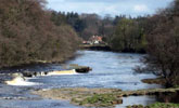
The River Tees. The River Tees meanders across a narrow floodplain between low river terrace bluffs of pasture, rough pasture or broadleaved woodland, or flows through narrow wooded denes flanked by low scars. Narrow riparian woodlands line the banks of the river. The floodplain is a mosaic of arable fields and improved or semi-improved pastures, open in places, divided in others by old hedges with scattered hedgerow trees. Fragments of rigg and furrow survive in the less improved pastures. Small green villages, hamlets, halls and building clusters line the river terraces above the floodplain.
Local Landscape Types
Local Landscape Types and sub-types are identified at a detailed level and reflect localised variations in landscape characteristics. A map of the Local Landscape Types and sub-types for the Lowland River Terraces Broad Landscape Type can be downloaded as a PDF below:
Local Landscape Types – Lowland River Terraces Map (PDF, 576kb)
Alternatively you can view an interactive map of Local Landscape Types for the whole of the Tees Lowlands County Character Area.
For a written description of the Local Landscape Type and sub-types for the Tees Lowlands County Character Areas download the following PDF:
Tees Lowlands Local Landscape Types (PDF, 1Mb)
Further Information
Further Broad Landscape Types with in the Tees Lowlands
or