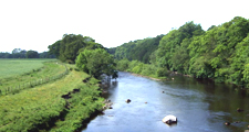
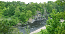
Lowland River Terraces
Land Management
Natural Features, Watercourses and Wetlands
- Protect and restore the natural character of watercourses and wetlands.
- Restore natural conditions to floodplains where possible as part of integrated flood storage and landscape restoration schemes.
- Fence rivers, streams and wetlands against livestock to prevent erosion and allow regeneration of bank-side vegetation.
- Protect ponds from drainage or infilling. Restore former ponds and create new ponds on suitable sites.
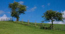
Farmland
- Establish uncultivated margins along hedgerows, woodland edges and watercourses.
- Avoid cultivation under the canopy of hedgerow and field trees.
- Maintain and enhance semi-improved or wet pastures and meadows by adopting appropriate stocking levels or cutting regimes. Avoid improvements such as drainage, ploughing and reseeding. Limit the use of fertilisers and herbicides.
- Restore diversity or wetness to improved pastures where possible – and particularly those of the floodplain and steeper bluffs.
Trees, Woodlands and Forestry
- Protect and conserve the broadleaved woodlands of steep riverside bluffs, incised denes and river banks.
- Extend existing woodlands through natural regeneration or planting with native species of local origins – oak woods on bluffs and river terraces, alder on river banks and streamsides and on wet or seasonally flooded haughs.
- Protect and maintain existing hedgerow trees and tree lines. Plant new hedgerow trees (Ash, Common Oak) or tag saplings to replace the maturing stock. Plant new tree lines – (Alder, Crack Willow) on river, ditch and streamsides.
Field Boundaries
- Protect and maintain hedgerows. Renovate overgrown and gappy hedges by laying or coppicing and gapping up.
- Allow trimmed hedges to grow higher and broader. Consider trimming every second or third year rather than annually.
- Reinstate hedges where they have been replaced by fences.
Cultural Features
- Protect archaeological features including rigg and furrow from damaging activities such as cultivation, tree planting or poaching by stock.
Development
Agricultural Buildings
- Site new farm buildings close to existing buildings where possible, and reflect their scale, character and materials. Avoid steeply sloping sites.
- Reduce the impact of larger modern buildings by careful selection of colour, breaking up mass and planting screening belts of native species.
Housing and Economic Development
- Maintain the rural character of the landscape generally by protecting it from significant new built development.
- Protect and conserve the character of villages by ensuring that new development respects their scale, structure and vernacular character.
- Retain open green spaces within villages, and particularly village greens, old gardens and orchards, and tofts or garths.
- Design any essential development so that it doesn’t compromise the natural hydrology of the floodplain.
Energy, Telecommunications and Infrastructure
- Site communications masts on buildings in urban areas where possible – or close to existing buildings, tree groups or woodland edges in the open countryside. Avoid prominent local skylines and particularly the edges of river terraces.
- Avoid ‘urban’ detailing and street lighting on country roads.
Tourism and Recreation
- Tourism and recreational development should be undertaken in such a way as to avoid any urbanising influence on the landscape. New buildings should, where possible, reflect the scale, form, materials and vernacular detailing of traditional farm buildings in the area.
- Facilities like chalets and caravan parks should only be developed or extended where there is a high degree of year-round visual containment – either from the topography or robust woodland cover – so that they do not detract from the rural character and scenic quality of the area.