Gritstone Upland Fringe
View interactive map of Broad Landscape Types
Key Characteristics
- Broad ridges and plateaux.
- Gently rounded topography of thinly bedded sandstones, limestones and mudstones overlain by glacial boulder clay.
- Small becks, occasionally in narrow incised valleys.
- Heavy, seasonally waterlogged clay soils.
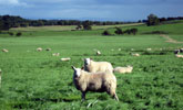
- Pastoral land use of improved, semi-improved or wet rushy pasture.
- Regular grids of parliamentary enclosures bounded by dry stone walls or hawthorn hedges, often gappy and overgrown. Occasional older field systems.
- Few trees – scattered hedgerow oak and ash.
- Variable woodland cover – generally sparsely wooded but with scattered conifer plantations in places.
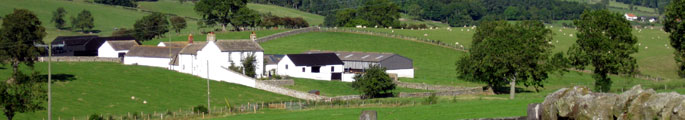
- Isolated farms connected by straight enclosure roads. Farms of the Raby estate north of the Tees are painted white.
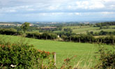
- A visually open landscape, broad in scale though locally defined by minor ridgelines and with occasional panoramic views across the Tees vale.
- A remote and tranquil rural landscape.
Description
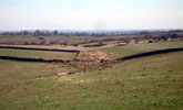
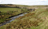
An upland fringe landscape of broad, high ridges and plateaux and shallow valleys. Thinly bedded sandstones, limestones and mudstones ground down by glacial ice sheets are overlain by boulder clays giving rise to gently rolling rounded topography. Thicker, more resistant sandstone beds are marked very occasionally by steeper bluffs. Small becks drain the plateaux and valleys, some lying in shallow incised denes. Soils are heavy, seasonally waterlogged clays with pockets of lighter brown earths.
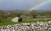
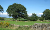
A pastoral landscape of improved and semi-improved pastures with occasional rougher grazing and wet rushy pasture. Field boundaries are a mixture of dry stone walls and hedgerows. Walls are made of locally quarried sandstones and limestones. Hedges are dominated by hawthorn and are often tall, leggy and grazed through or supplemented by wire fences. Field systems are regular in pattern, dating from the enclosure of moorland wastes in the 18th century. Older, pre-enclosure, field systems are found locally but are very similar in character.
Tree cover is low, with scattered hedgerow oak and ash, occasional lines of alder along watercourses and tall overgrown hedgerow hawthorn trees. Woodland cover varies – generally the landscape is very open but some areas are relatively well wooded with scattered plantations of pine or larch.
A sparsely settled landscape of isolated farms connected by straight enclosure roads. Buildings are of local stone with roofs of stone flag or welsh slate. Farms and farm buildings of the Raby estate, covering most of the land north of the Tees, are painted white.
The landscape is visually open and broad in scale though locally defined by minor ridgelines. From some vantage points there are panoramic views across the Tees vale and west into Teesdale from higher ground. A remote and tranquil rural landscape.
Broad Character Areas
The Gritstone Upland Fringe landscape type is represented by three Broad Character Areas.

View interactive map of Broad Character Areas Map
Bowes. An area of high almost flat ground on the edges of the moorland plateau of the Stainmore Gap. An open pastoral landscape of improved pasture and wet, rushy pasture with few trees or woodlands. Regular grids of parliamentary enclosures cover much of the area. In the north across Deepdale, large fields are bounded by dry stone walls. East of Bowes, narrow linear parliamentary enclosures and older curvilinear town field enclosures are bounded by a mixture of leggy, overgrown hedges and stone walls with scattered, locally abundant, ash and Sycamore trees. Isolated farms are scattered across the area.
Moorhouse and Gill Beck. Areas of high, almost flat ground either side of the River Greta. An open pastoral landscape of improved pasture and wet, rushy pasture with few trees and scattered conifer plantations and shelterbelts. Regular systems of parliamentary enclosures are crossed by straight enclosure roads. Field boundaries are a mixture of stone walls and leggy, overgrown hedges. Isolated farms are scattered across the area.
Raby Hill, Marwood and Kinninvie. An area of high ridges and valleys and gently rolling plateaux drained by the Langley and Forthburn becks. A pastoral landscape of improved and semi-improved pasture with scattered conifer plantations. Heavily wooded estate farmland lies on the high northern ridge at Raby Hill. Regular grids of parliamentary enclosures are crossed by straight enclosure roads. Field boundaries are largely trimmed hedgerows with scattered oak, ash and sycamore trees. Isolated farms – many of them painted white – are scattered across the area.
Local Landscape Types
Local Landscape Types and sub-types are identified at a detailed level and reflect localised variations in landscape characteristics. A map of the Local Landscape Types and sub-types for the Gritstone Upland Fringe Broad Landscape Type can be downloaded as a pdf below:
Local Landscape Types – Gritstone Upland Fringe Map (PDF, 804kb)
Alternatively you can view an interactive map of Local Landscape Types for the whole of the Dales Fringe County Character Area.
For a written description of the Local Landscape Type and sub-types for the Dales Fringe County Character Areas download the following pdf:
Dales Fringe Local Landscape Types (PDF, 672kb)
Further Information
Further Broad Landscape Types with in the Dales Fringe
or