Wear Lowlands Assets and Attributes
Landscape Designations
The incised valley landscapes of the Wear Lowlands are designated as Area of High Landscape Value (AHLV) in Local Plans.
- View Landscape Designations map
International Nature Conservation Designations
None.
National and Local Nature Conservation Designations
There are three Site of Special Scientific Interest (SSSI), in the Wear lowlands. Waldridge Fell is the last lowland heath in the area. Brasside Pond and Low Butterby Oxbow are wetlands. There are a large number of County Wildlife Sites (now know as Local Wildlife Sites), mostly ancient woodlands.
Biodiversity Action Plan Priority Habitats and Species
The landscape is important for a number of national and local Biodiversity Action Plan priority habitats and species.
Priority habitats in the Durham Biodiversity Action Plan (DBAP) represented in the Wear Lowlands include:
- Ancient Semi Natural Woodland
- Other Broadleaved Woodland
- Native Hedgerows
- Parkland
- Scrub
- Veteran Trees
- Wet Woodland
- Wood Pasture
- Floodplain Grazing Marsh
- Lowland Fen Habitats
- Phragmnites Australis Reedbed
- Ponds
- Rivers and Streams
- Early succesional Brownfield Land
- Lowland Heath
- Lowland Meadows and Pasture
- Road Verges of Conservation Importance
- Waxcap Grasslands
Priority species in the Durham Biodiversity Action Plan (DBAP) found in the Wear Lowlands include:
- Badger
- Bats
- Brown Hare
- Harvest Mouse
- Hedgehog
- Otter
- Water Vole
- Barn owl
- Curlew
- House Sparrow
- Lapwing
- Linnet
- Redshank
- Reed Bunting
- Skylark
- Snipe
- Song Thrush
- Spotted Fly-catcher
- Starling
- Tree Sparrow
- Yellow Wagtail
- Adder
- Common Lizard
- Grass Snake
- Slow Worm
- Great crested Newt
- Eel
- Salmon
- Trout
- Dingy Skipper
- Green Hairstreak
- White-letter Hairstreak
- Black poplar
- Juniper
Habitat Networks
Semi-natural habitats occupy a relatively small proportion of the Wear Lowlands. The majority of grasslands are improved with scattered patches of semi-improved pasture and lowland heath. The woodland network is more robust with fairly well connected riparian corridors of woodland along the Wear and its tributaries, and substantial areas of heavily wooded estate landscapes. There are many gaps in the woodland habitat network, some due to built development, and many woods have been re-stocked, which can affect their value as networks for some species – as can their relatively modest scale. Early successional brownfield land occurs in both isolated pockets and in linear corridors following former rail and waggonways. Wetland habitats occur generally as thinly scattered and isolated features on the floodplain. The quality of some tributary streams is affected by mine-water pollution which affects their value as networks for many species. The overall pattern of habitat distribution closely reflects the topography, with most semi-natural habitats found along the incised corridors or rivers and streams separated by extensive areas of farmland or built development.
- View Habitat Network Map
Ancient Semi-natural Woodlands
The incised valley landscape of the Wear contains a large number of ancient semi-natural woodlands in denes and ravines, on steep riverside bluffs and along riverbanks on the floodplain.
- View Ancient Woodland Map
Earth Heritage Designations
The area contains two County Geological Sites: a river section in the Wear Gorge at Durham and geomorphological features – sub-glacial channels – near Sacriston on the western valley terraces.
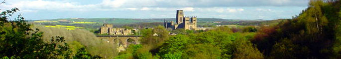
World Heritage Site The Durham Castle and Cathedral World Heritage Site is located in the centre of the Wear Lowlands. Much of the surrounding landscape is important to its setting, and views of the cathedral are important from much of that area.
- View an interactive map of World Heritage Site
Archaeological Sites and Monuments
The landscape contains archaeological remains from the Neolithic period onwards, many of which are recorded in the Durham Sites and Monuments Record (SMR). Scheduled Ancient Monuments include a large number of medieval features – bridges, monasteries, chapels and hospitals – as well as roman (Congangium Fort at Chester-le-Street) and prehistoric features.
Built Heritage
Many of the older villages, together with the historic city centre of Durham, terraced housing in Bowburn and several historic parklands, are designated as Conservation Areas. The Wear Lowlands are particularly rich in listed buildings – including domestic and ecclesiastical buildings and castles.
- View Built Heritage Map
Historic Parks and Gardens
The Wear Lowlands is notable for its historic parks and gardens, five of which (Brancepeth, Burn Hall, Croxdale, Lumley and Lambton) are on English Heritage‘s Register of Parks and Gardens of Special Historical Interest.
- View interactive map Registered Parks and Gardens
Access, Recreation and Tourism
The network of public rights of way is well developed in places, and particularly around former mining settlements and older villages. Access is very limited on some of the larger estates. The Weardale Way follows the course of the River Wear in places, but is diverted away from the river in places in the absence of public rights of way, again particularly around private estates.
Water Resources
Water quality in the River Wear is variable from good to fair. In some of its tributaries, and in the River Team to the north, quality is only fair, poor and locally bad as a result of discharges from mine workings, treatment works, storm sewage overflows and surface water drainage from industrial and agricultural activities. Parts of the valley terraces lie in a Nitrate Vulnerable Zone.
- View Water Resources Map
Agricultural Land Classification
There are areas of Grade 2 (very good) agricultural land along the floodplain of the River wear. Elsewhere agricultural land is largely Grade 3 (moderate and good) with small pockets of Grade 4 (poor) in steep sided valleys and on some reclaimed land.