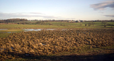
Lowland Carrs
Land Management
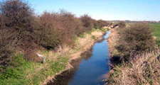
Natural Features, Watercourses and Wetlands
- Restore natural hydrological conditions to the carrs where possible as part of integrated flood storage and landscape restoration schemes.
- Restore the natural meandering course of the River Skerne.
- Protect and conserve natural ponds and flashes.
- Manage drainage ditches to conserve their wildlife value by maintaining high water levels, creating stepped profiles and leaving sections or banks undisturbed during maintenance works.
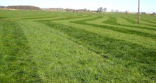
Farmland
- Conserve and enhance wet pastures by maintaining or raising water levels, allowing seasonal flooding, adopting appropriate stocking levels and avoiding improvements such as drainage, ploughing and reseeding. Limit the use of fertilisers and herbicides.
- Restore former wet pastures by reversion from arable to pasture and raising water levels.
- Establish permanent uncultivated grassland margins along hedgerows, ditches and watercourses.
Trees, Woodlands and Forestry
- Maintain the openness of the carr landscape generally.
- Plant individual trees (Crack Willow, Black Poplar) and tree lines along ditches and watercourses.
- Plant new native alder woods – and particularly in the edges of the carrs or in areas modified by road and railway lines.
Field Boundaries
- Protect and maintain existing hedgerows in the carrs fringe.
- Renovate overgrown or gappy hedges by laying or coppicing and gapping up. Allow trimmed hedges to grow higher and broader. Consider trimming every second or third year rather than annually.
- Restore old field patterns in the carrs fringe by reinstating hedges.
- Conserve hedgerow trees in the carrs fringe – avoid close cultivation in arable fields. Plant new hedgerow trees (Ash) in areas where they are characteristic.
Cultural Features
- Protect archaeological features including rigg and furrow from damaging activities such as cultivation, overstocking, or poaching.
Development
Agricultural Buildings
- Avoid siting new farm buildings on the flat land of the carrs. Where possible site them on adjacent areas of higher ground, close to existing farmsteads, reflecting their scale, character and materials.
- Reduce the impact of larger modern buildings by careful selection of colour, breaking up mass and planting screening belts of native species.
Housing and Economic Development
- Maintain the undeveloped character of the carrs by avoiding new development.
- Screen any essential new development with substantial structure planting of native oak (dry ground) or alder (wet ground) woodland.
Energy, Telecommunications and Infrastructure
- Avoid siting communications masts in the open landscape of the carrs – where possible site them in adjacent urban areas or close to existing buildings, tree groups or woodland edges in the Lowland Plain landscapes fringing the carrs.
- Avoid siting wind energy development on the open carrs – consider alternative locations in the carr fringes.