Coalfield Upland Fringe
Land Management
Natural Features, Watercourses and Wetlands
- Protect the banks of streams from livestock to prevent erosion and allow natural regeneration of bank-side vegetation.
Moor and Heath
- Protect and conserve heaths and fells by adopting appropriate grazing or cutting regimes and controlling motorcycle scrambling, fly tipping and illegal grazing.
- Restore damaged heathland by removing conifer plantations or reducing stocking levels. Create new heathland on suitable sites – particularly those with impoverished, acidic or disturbed soils – using locally sourced heather litter or seed.
Farmland
- Maintain and enhance semi-improved pastures and meadows, wet pastures and rough grazing by adopting appropriate stocking levels or cutting regimes and avoiding improvements such as drainage, ploughing and reseeding. Limit the use of fertilisers and herbicides.
- Restore former meadows and restore diversity to improved pastures where possible by reseeding or the use of hay crops from local meadows as a seed source.
Trees, Woodlands and Forestry
- Protect and maintain existing hedgerow trees. Plant new field boundary trees (Ash, Sessile Oak, Rowan) – and particularly on restored opencast land – or tag saplings to replace the maturing stock.
- Conserve roadside trees and scrub – and particularly along enclosure roads.
- Plant new native oak or oak-birch woodlands along denes and steep valley side bluffs and alder woods along streamsides.
- Plant new medium or large scale mixed or broadleaved woodlands and particularly on former opencast land and close to settlement edges.
- Increase the proportion of locally native species when restocking plantations.
- Plant small woodlands and tree groups to screen larger modern farm buildings.
Cultural Features
- Protect archaeological features by avoiding overstocking or supplementary feeding on sensitive sites.
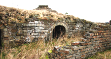
- Protect and conserve mining-related features such as old drifts, spoil heaps, coke ovens, waggonways and lime kilns. Avoid physical damage, removal or infilling. Consolidate important structures taking archaeological advice.
- Conserve and maintain traditional field barns and farm buildings.
Field Boundaries
- Protect, restore and maintain existing dry stone walls and hedgerows. Renovate overgrown and gappy hedges by laying or coppicing and gapping up.
- Reinstate hedges and walls where they have been replaced by fences – particularly in areas of older enclosure, along enclosure roads and lanes, and on reclaimed or restored opencast land.
Development
Agricultural Buildings
- Site new farm buildings close to existing buildings where possible, and reflect their scale, character and materials. Reduce the impact of larger modern buildings by careful selection of colour, breaking up mass and planting screening belts of native species.
Energy, Telecommunications and Infrastructure
- Site communications masts on buildings in urban areas where possible – or close to existing buildings, tree groups or woodland edges in the open countryside. Avoid prominent skylines.
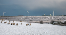
- Give careful consideration to the siting, layout and design of new wind energy developments having particular regard to cumulative impacts and the relationships of nearby developments in terms of turbine size and type.
- Avoid regular layouts. Break larger developments into discrete clusters to reflect the scale of the local topography. Avoid locating large turbines close to existing rural features such as farmsteads that might emphasise their scale.
- Take account of visual impacts on adjacent landscapes – particularly the finer grained Coalfield Valleys and the wild Moorland Ridges and Summits.
Housing and Economic Development
- Maintain the separation of villages and the rural character of the countryside between them in planning for new development.
- Screen new development on settlement edges with substantial structure planting of native woodland.
- Avoid prominent ridge top or sloping valley side sites for new development or incorporate substantial internal structure planting.
Minerals and Waste
- Avoid damage to sensitive natural landforms.
- Avoid breaching local skylines with extraction areas or storage mounds.
- Restore sites to semi-natural oak and oak-birch woodland, mid-altitude heathland, acid and neutral grassland, wetland, and bare rock habitats using natural regeneration where appropriate.
- Adopt low intervention approaches to the reclamation of former colliery and industrial land where possible to preserve the landscape’s industrial heritage and ‘brownfield’ biodiversity.
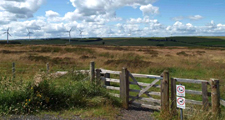
Tourism and Recreation
- Tourism and recreational development should be undertaken in such a way as to avoid any urbanising influence on the landscape.
- Facilities like chalets and caravan parks should only be developed or extended where there is a high degree of year-round visual containment – either from the topography or robust woodland cover – so that they do not erode the rural character of the area.
- Golf course development should seek to conserve and reinforce landscape character by retaining mature landscape features and planting new native woodlands and parkland trees. Avoid prominent locations for built elements like buildings, driving ranges and ball-trap fencing. Develop species rich grassland or mid-altitude heath in roughs to increase biodiversity.
- Equestrian facilities should be sited close to existing farm buildings where possible, and reflect their scale, character and materials. The impact of larger buildings should be reduced by careful selection of colour, breaking up mass, and planting screening belts of native woodland.
Further Information
- Description of Coalfield Upland Fringe Landscape Character
- West Durham Coalfield Strategy