Woodland and Forestry
The distribution of woodland in the county reflects thousands of years of human activity in woodland clearance and planting. Woodland cover is relatively low, around 6% compared to the national average of 9% and the average for England of 7.5%. Woodlands are absent from the upland moors. Heavily wooded landscapes occur locally elsewhere and particularly in the main river valleys.
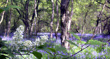
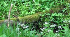
Ancient semi-natural woods occupy around 1.3% of the County. Most ancient woods lie on land unsuitable for agriculture on steep valley sides and ravines along rivers and streams.
View map of the distribution of Ancient Woodland in County Durham.
Oak and Oak-birch woodlands are typical of the acidic and neutral soils that cover much of the county. Ash woodlands are found on the limestones of upland gills and ravines and coastal denes. Fragments of Juniper woodland survive in the moorland margins, including one of the largest stands of Juniper in Britain in the Moor House – Upper Teesdale National Nature Reserve. Alder woodlands occur locally on wetter ground.
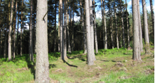
The majority of woodlands in the county are plantations, established for timber, landscape, amenity, shelter and game. Many older woods were planted with natives or introduced broadleaves like beech and sycamore. The planting of conifers such as Scots Pine and Larch – often with local markets for pit-wood in mind – became widespread in the 19th century.
View map of the distribution of Plantation and Secondary Woodland in County Durham.
This continued into the 20th century with the development of large Forestry Commission forest including Hamsterley Forest and The Stang in the upland fringes where Sitka Spruce is an important commercial species. Around a third of the County’s woodlands are in public ownership, with the Forestry Commission owning the greater part of this. The County Council owns and manages around 1000 hectares of woodland, much of this on reclaimed former colliery land.
The Great North Forest, established in 1990, is one of twelve Community Forests being created across England to regenerate the countryside around major towns and cities. The Great North Forest was established in 1990 and now covers approximately 250 square kilometres of urban fringe countryside across Tyne and Wear and north-east Durham.
Further Information
- The County Durham Landscape Strategy for Woodlands and Forestry.
- Natural England’s Inventory of Ancient Woodlands is available to view online or download from the Multi-Agency Geographic Information for the Countryside (MAGIC) website.