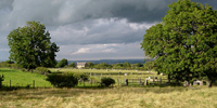
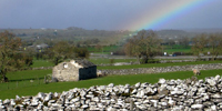
• Skip to main content
  • Skip to primary sidebar
Durham Landscapes

Understanding and conserving the diversity of the County Durham Landscape

  • Character
  • Strategy
  • Guidelines
  • Curlew - Copyright www.northeastwildlife.co.ukAssets and Attributes
  • Sunrise, Boldron © Copyright Andy Waddington. Licensed for reuse under a Creative Commons Licence (see Legal Information)Strategy
  • Dales Fringe Farmland © Copyright Andy Waddington. Licensed for reuse under a Creative Commons Licence (see Legal Information)Current Initiatives
  • Drystone Walls, Bowes © Copyright Andy Waddington. Licensed for reuse under a Creative Commons Licence (see Legal Information)Trends and Pressures

Dales Fringe

The following pages contain analysis of the assets and attributes of the Dales Fringe, strategic objectives and spatial strategies, the trends and pressures affecting it and key issues for action.

Primary Sidebar

  • County Durham Landscape Strategy
  • Strategy Overview
    • The Landscape Strategy
    • Methodology
  • Broad Issues
    • Climate Change
    • Biodiversity
    • Geodiversity
    • Cultural Heritage
    • Tranquillity
    • Green Infrastructure
  • Land Management
    • Agriculture
    • Woodland and Forestry
    • Moors and Heath
    • Field Boundaries
    • Rivers and Wetlands
    • Designed Landscapes
  • Development
    • Housing
    • Industry
    • Transport
    • Minerals
    • Waste
    • Renewable Energy
    • Recreation and Tourism
  • County Character Area Strategies
    • Dales Fringe
    • North Pennines
    • Wear Lowlands
    • West Durham Coalfield
    • East Durham Limestone Plateau
    • Tees Lowlands

  • About this Website |
  • Accessibility Statement |
  • Legal Information |
  • Contact Us |
  • Maps
  • Copyright © 2025 Developed by Durham County Council.
Durham County Council Logo
Top of page