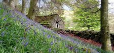
Tranquillity
Tranquillity is one of the less easily defined attributes of the countryside but also one of the most important to the communities who live there and the people who visit it for recreation and relaxation.
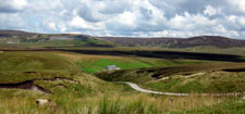
A Government survey in 2001 found that tranquillity was the positive feature people mentioned most in describing why they visited the countryside. The North East has some of the most tranquil landscapes in the country and these are a major asset to the tourism economy.
The tranquillity of the countryside has been progressively eroding for decades under the impact of urban sprawl, increased traffic levels, the development of new roads and infrastructure, increases in air traffic and increasing levels of light pollution. In 1995 the Campaign to Protect Rural England (CPRE) carried out a study to map changes in tranquillity in the English countryside. They found that England had lost 21% of its Tranquil Areas (19,000km2) since the 1960s, equivalent to an area almost the size of Wales. Responding to CPRE’s work on tranquillity, the Government’s Rural White Paper in 2000 included a commitment to promote tranquillity and to produce a National Ambient Noise Strategy.
Mapping Tranquillity
A recent study on tranquillity was carried out by the CPRE in the North East Region (Mapping Tranquillity CPRE 2005) to investigate ways of mapping tranquillity at a more detailed level in two pilot areas – the Northumberland National Park and the Durham Coalfield. The study provides the basis of a methodology which could be a extended to map levels of tranquillity for County Durham as a whole
Conserving and Restoring Tranquillity
Conserving and, where possible, restoring tranquillity will require concerted action by a large number of organisations and individuals. Further work is needed to provide guidance on issues like noise and light pollution and to ensure that the impacts of new development on tranquillity are taken into account in the environmental impact assessment and planning processes.
Objectives
- To support and encourage the mapping of tranquillity in County Durham.
- To support the production of guidance on tranquillity issues in Supplementary Planning Documents.