• Skip to main content
  • Skip to primary sidebar
Durham Landscapes

Understanding and conserving the diversity of the County Durham Landscape

  • Character
  • Strategy
  • Guidelines
  • Scoberry Bridge to Dine Holme Scar Local Geological Site

Geological Sites

The county contains a large number of sites designated as County Geological/Geomorphological Sites (CGS) now know as Local Geological Sites. These range from old mines and quarries to glacial features including drumlins and melt water channels. Moking Hurth Cave is designated as a Regionally Important Geological Site (RIGS). County Geological Sites do not have the same statutory protection as Sites of Special Scientific Interest (SSSIs).
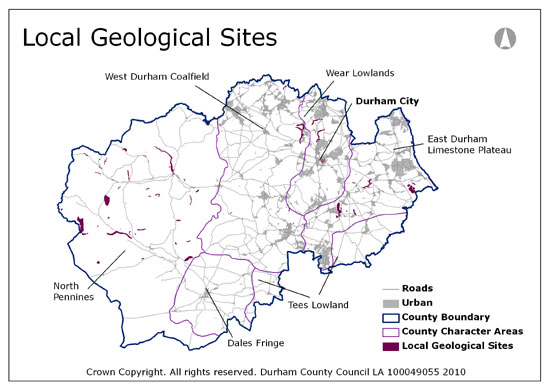
Local Geological Sites

Local Development Plans contain policies for their conservation, for example, by not permitting development to take place that would damage their geodiversity interest.

Primary Sidebar

  • County Durham Landscape Character
  • The Durham Landscape
    • Physical Influences
    • Human Influences
    • The Modern Landscape
    • Perceptions of the Landscape
    • Designated Landscapes
  • Character Overview
    • The Landscape Character Assessment
    • Assessment Methodology
  • Character Areas and Types
    • County Character Areas
    • Broad Landscape Types and Character Areas
    • Local Landscape Types and Subtypes
    • Landscape Classification

  • About this Website |
  • Accessibility Statement |
  • Legal Information |
  • Contact Us |
  • Maps
  • Copyright © 2025 Developed by Durham County Council.
Durham County Council Logo
Top of page