• Skip to main content
  • Skip to primary sidebar
Durham Landscapes

Understanding and conserving the diversity of the County Durham Landscape

  • Character
  • Strategy
  • Guidelines
  • Pennines Dale Environmentally Sensitive Area

Environmentally Sensitive Areas

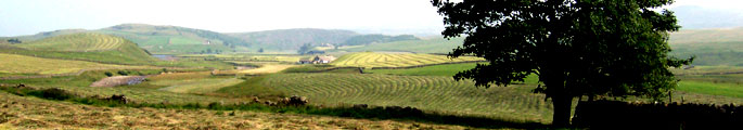
The Pennine Dales ESA covers a number of upper dales in Durham. Their value lies in their old hay meadows and pastures, stone walls, field barns, small woods and field trees. They contain valuable wildlife habitats, a rich archaeological resource and a landscape of strong character, all dependent in some degree on traditional farming practices.

Environmentally Sensitive Areas

The ESA scheme is administered by the Department of Environment, Food and Rural Affairs (DEFRA) which offers incentives to adopt agricultural practices which safeguard and enhance the rural environment and to improve public access.

The scheme has now closed to new applicants and has been superseded by the Environmental Stewardship scheme. Some existing agreements will, however, continue until 2014.

Further Information

The boundaries of the Pennine Dales ESAs are available to view and download from the Multi-Agency Geographic Information for the Countryside (MAGIC) website.

Primary Sidebar

  • County Durham Landscape Character
  • The Durham Landscape
    • Physical Influences
    • Human Influences
    • The Modern Landscape
    • Perceptions of the Landscape
    • Designated Landscapes
  • Character Overview
    • The Landscape Character Assessment
    • Assessment Methodology
  • Character Areas and Types
    • County Character Areas
    • Broad Landscape Types and Character Areas
    • Local Landscape Types and Subtypes
    • Landscape Classification

  • About this Website |
  • Accessibility Statement |
  • Legal Information |
  • Contact Us |
  • Maps
  • Copyright © 2025 Developed by Durham County Council.
Durham County Council Logo
Top of page