20th Century
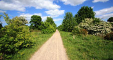
The coal and steel industries of the area began to decline in the 1930’s and continued to do so into the 1980’s which saw the last of the major collieries and steel works close. Their legacy of physical dereliction and social deprivation was addressed by a succession of reclamation and infrastructure projects which saw substantial areas of derelict land reclaimed to new housing and industry or agriculture and forestry. Some elements of the industrial landscape survive and are preserved as part of the county’s industrial heritage. Many abandoned railway lines and tramways have been converted into cycleways and recreational trails.
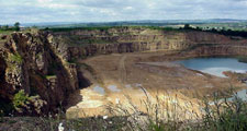
Since 1945 opencast coal mining has had a significant impact on the landscape with extensive areas worked and restored, often to rather featureless agricultural land. Quarrying for whinstone, dolomite and limestone also increased in scale over the century creating many large quarries, many of which now lie abandoned, on the limestone escarpment and in the Pennine dales.
Mining towns and villages continued to grow throughout the 20th century with large new public housing estates built in the interwar and post-war period. Some smaller mining villages were demolished or reduced in size through a policy of consolidation in the 1970’s. New Towns were built at Newton Aycliffe and Peterlee. As the economy restructured, new industries were accommodated in urban fringe industrial estates around larger towns and villages and new and improved highways were developed to serve them.
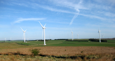
Changing agricultural practices in the latter part of the century brought considerable change to parts of the countryside. A renewed emphasis on arable farming in eastern and central areas led to increases in field sizes, removal of hedgerows, hedgerow trees and wetlands and the introduction of new crops like oilseed rape. In pastoral areas changes in grassland management, improvement of old pastures and meadows and a move from hay cropping to silage production have created more uniform and productive grasslands. Employment in agriculture declined significantly over the century bringing a shift from agricultural to residential occupancy in farms and villages across the county, and changing working and commuting patterns in rural areas. The 20th century also saw the introduction of many new features into to the landscape including overhead power lines, telecommunication masts and, most recently, wind turbines.